Regent's Slide

Regent’s Slide, Big Sur, California
Regent’s Slide, Big Sur, California
Regent’s Slide, Big Sur, California
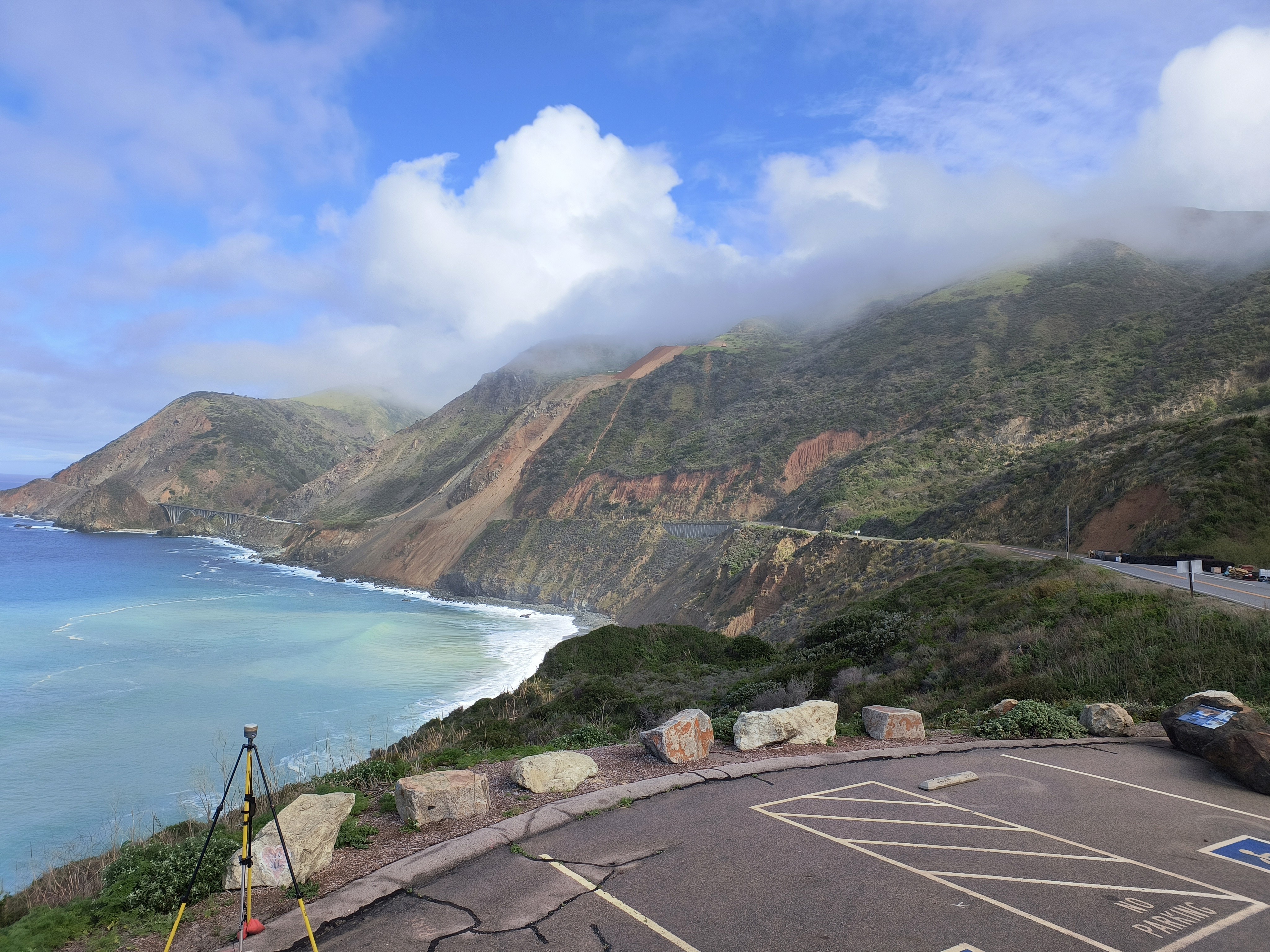
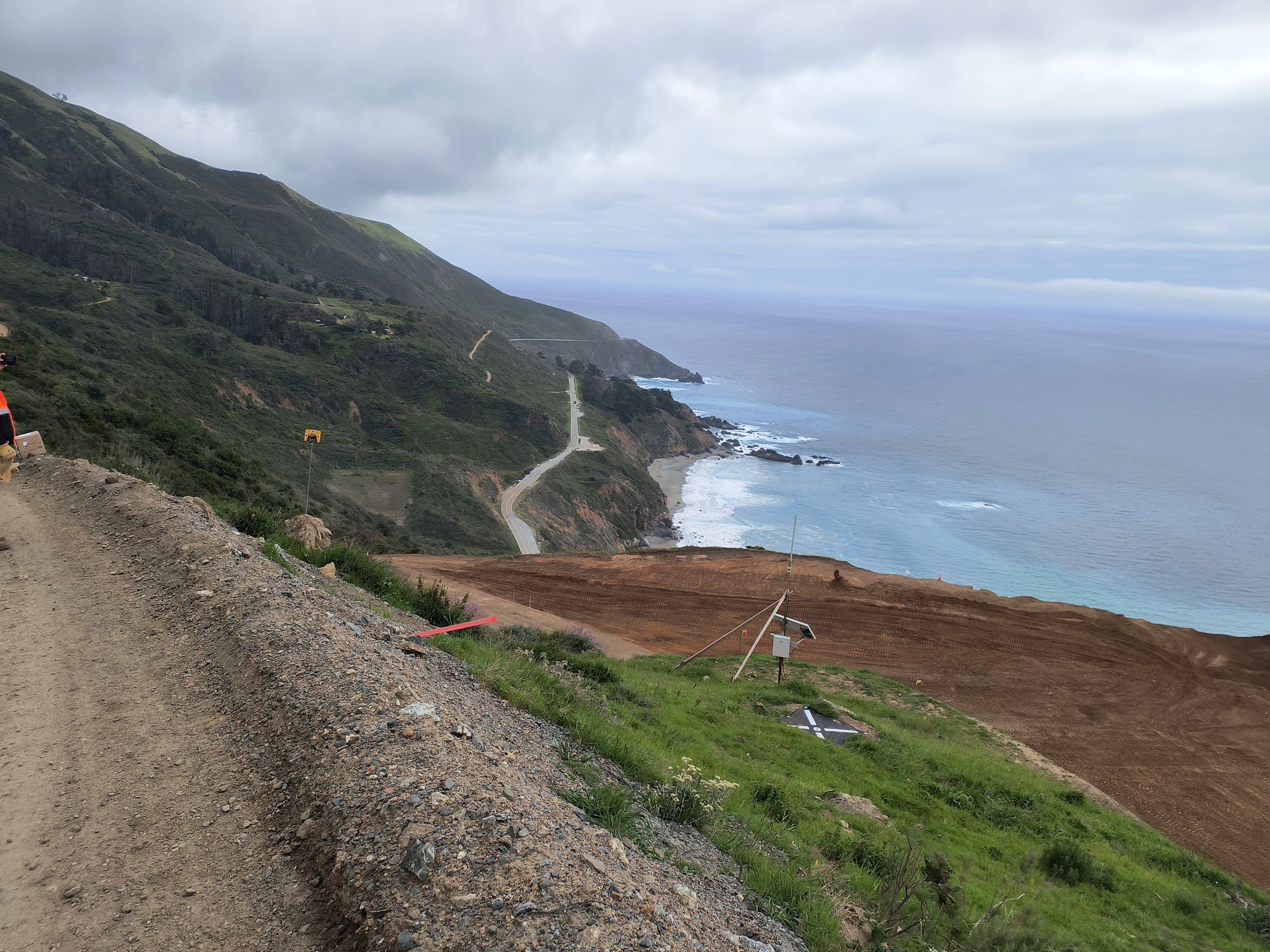
Regent's Slide is a major coastal landslide located along California State Route 1 in Big Sur, an area where steep coastal terrain, fractured rock, and seasonal moisture make slope instability a recurring challenge. In early 2024, a significant slope failure destroyed part of the highway, cutting off access along one of California’s most important coastal transportation routes and creating immediate concerns for public safety, emergency access, and long-term roadway restoration.
The slide proved difficult to stabilize because movement continued beyond the initial failure zone. As excavation and material removal began, additional portions of the hillside kept moving farther upslope, making it difficult to define the true failure plane and determine when crews could safely continue work. This created both construction risk and uncertainty for project planners, since removing unstable material too early could trigger further movement, while waiting too long would extend closures and increase project costs.
Because of these conditions, continuous geotechnical monitoring became necessary to understand how the slope was behaving in real time, identify where stable ground existed beneath the slide mass, and provide engineers with data that could support safe decision-making during excavation and stabilization efforts.
Regent's Slide is a major coastal landslide located along California State Route 1 in Big Sur, an area where steep coastal terrain, fractured rock, and seasonal moisture make slope instability a recurring challenge. In early 2024, a significant slope failure destroyed part of the highway, cutting off access along one of California’s most important coastal transportation routes and creating immediate concerns for public safety, emergency access, and long-term roadway restoration.
The slide proved difficult to stabilize because movement continued beyond the initial failure zone. As excavation and material removal began, additional portions of the hillside kept moving farther upslope, making it difficult to define the true failure plane and determine when crews could safely continue work. This created both construction risk and uncertainty for project planners, since removing unstable material too early could trigger further movement, while waiting too long would extend closures and increase project costs.
Because of these conditions, continuous geotechnical monitoring became necessary to understand how the slope was behaving in real time, identify where stable ground existed beneath the slide mass, and provide engineers with data that could support safe decision-making during excavation and stabilization efforts.
Regent's Slide is a major coastal landslide located along California State Route 1 in Big Sur, an area where steep coastal terrain, fractured rock, and seasonal moisture make slope instability a recurring challenge. In early 2024, a significant slope failure destroyed part of the highway, cutting off access along one of California’s most important coastal transportation routes and creating immediate concerns for public safety, emergency access, and long-term roadway restoration.
The slide proved difficult to stabilize because movement continued beyond the initial failure zone. As excavation and material removal began, additional portions of the hillside kept moving farther upslope, making it difficult to define the true failure plane and determine when crews could safely continue work. This created both construction risk and uncertainty for project planners, since removing unstable material too early could trigger further movement, while waiting too long would extend closures and increase project costs.
Because of these conditions, continuous geotechnical monitoring became necessary to understand how the slope was behaving in real time, identify where stable ground existed beneath the slide mass, and provide engineers with data that could support safe decision-making during excavation and stabilization efforts.
Monitoring Approach and System Deployment
Monitoring Approach and System Deployment
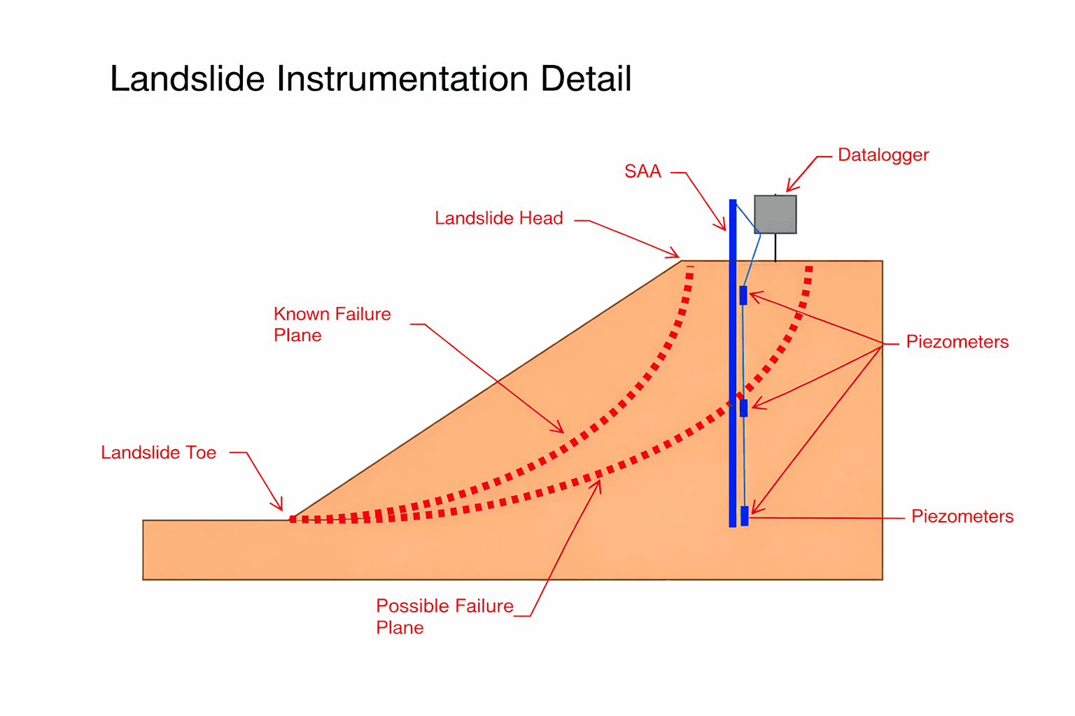
To support slope-stabilization efforts at Regent’s Slide, Measure installed multiple ShapeAccelArray systems across the active slide area to continuously track subsurface deformation and define the active failure zone. The arrays provided near-real-time movement profiles through the slope, helping engineers identify where displacement was occurring and where stable material began beneath the slide mass.
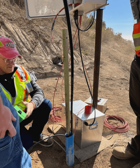
Each ShapeArray was connected to Campbell Scientific datalogger equipment that collected and stored movement data locally. Because the remote coastal site lacked reliable cellular coverage, radio communications transmitted data from each instrument location to a central datalogger. Starlink satellite internet then sent the data to a remote visualization platform, allowing authorized engineers and project managers to review slope movement from anywhere with internet access.
To support slope-stabilization efforts at Regent’s Slide, Measure installed multiple ShapeAccelArray systems across the active slide area to continuously track subsurface deformation and define the active failure zone. The arrays provided near-real-time movement profiles through the slope, helping engineers identify where displacement was occurring and where stable material began beneath the slide mass.
Each ShapeArray was connected to Campbell Scientific datalogger equipment that collected and stored movement data locally.
To support slope-stabilization efforts at Regent’s Slide, Measure installed multiple ShapeAccelArray systems across the active slide area to continuously track subsurface deformation and define the active failure zone. The arrays provided near-real-time movement profiles through the slope, helping engineers identify where displacement was occurring and where stable material began beneath the slide mass.
Each ShapeArray was connected to Campbell Scientific datalogger equipment that collected and stored movement data locally. Because the remote coastal site lacked reliable cellular coverage, radio communications transmitted data from each instrument location to a central datalogger. Starlink satellite internet then sent the data to a remote visualization platform, allowing authorized engineers and project managers to review slope movement from anywhere with internet access.
A robotic total station operated by another contractor also measured surface displacement, but it was not configured for automated remote monitoring. Engineers therefore visited the site about twice per week to collect those readings manually. The total station provided periodic surface-movement data, while the continuously connected ShapeArrays captured changing subsurface conditions between visits.
Together, the systems provided complementary, overlapping measurements of slope behavior. The remote monitoring architecture allowed the project team to review movement trends as excavation progressed, reducing dependence on difficult site visits and helping determine when work could continue safely or when additional caution was needed.
Because the remote coastal site lacked reliable cellular coverage, radio communications transmitted data from each instrument location to a central datalogger. Starlink satellite internet then sent the data to a remote visualization platform, allowing authorized engineers and project managers to review slope movement from anywhere with internet access.
A robotic total station operated by another contractor also measured surface displacement, but it was not configured for automated remote monitoring. Engineers therefore visited the site about twice per week to collect those readings manually. The total station provided periodic surface-movement data, while the continuously connected ShapeArrays captured changing subsurface conditions between visits.
Together, the systems provided complementary, overlapping measurements of slope behavior. The remote monitoring architecture allowed the project team to review movement trends as excavation progressed, reducing dependence on difficult site visits and helping determine when work could continue safely or when additional caution was needed.
A robotic total station operated by another contractor also measured surface displacement, but it was not configured for automated remote monitoring. Engineers therefore visited the site about twice per week to collect those readings manually. The total station provided periodic surface-movement data, while the continuously connected ShapeArrays captured changing subsurface conditions between visits.
Together, the systems provided complementary, overlapping measurements of slope behavior. The remote monitoring architecture allowed the project team to review movement trends as excavation progressed, reducing dependence on difficult site visits and helping determine when work could continue safely or when additional caution was needed.
Project Value
Project Value
Real-time monitoring allowed excavation crews to work more efficiently by showing when movement had stabilized and when it was safe to continue removing material. Instead of relying only on periodic field observations, the team could make decisions using continuous subsurface data. This reduced unnecessary stoppages, helped avoid over-excavation, and gave engineers confidence to advance work only when conditions supported it. The result was a faster, more informed construction effort supported by the field execution of California Department of Transportation and Papich Construction Company under extremely difficult slope conditions.
Real-time monitoring allowed excavation crews to work more efficiently by showing when movement had stabilized and when it was safe to continue removing material. Instead of relying only on periodic field observations, the team could make decisions using continuous subsurface data. This reduced unnecessary stoppages, helped avoid over-excavation, and gave engineers confidence to advance work only when conditions supported it. The result was a faster, more informed construction effort supported by the field execution of California Department of Transportation and Papich Construction Company under extremely difficult slope conditions.
Real-time monitoring allowed excavation crews to work more efficiently by showing when movement had stabilized and when it was safe to continue removing material. Instead of relying only on periodic field observations, the team could make decisions using continuous subsurface data. This reduced unnecessary stoppages, helped avoid over-excavation, and gave engineers confidence to advance work only when conditions supported it. The result was a faster, more informed construction effort supported by the field execution of California Department of Transportation and Papich Construction Company under extremely difficult slope conditions.
If you have questions about monitoring or it showed up in your scope and you're looking for solutions, call (909) 809-5559 or fill out the form.
Request a Quote