VTA BART Silicon Valley Phase II

VTA BART Silicon Valley Phase II

VTA BART Silicon Valley Phase II
CP2 West Portal 7A Geotechnical Instrumentation & Monitoring
Project Overview:
CP2 West Portal 7A Geotechnical Instrumentation & Monitoring
Project Overview:
CP2 West Portal 7A Geotechnical Instrumentation & Monitoring
Project Overview:
CP2 West Portal 7A Geotechnical Instrumentation & Monitoring
Project Overview:
The BART Silicon Valley Phase II (BSVII) Extension extends BART service six miles from Berryessa through downtown San Jose to the City of Santa Clara, featuring four new stations and approximately five miles of underground bored tunnel. Drawing on consulting experience with the LA Metro tunneling program, the Hong Kong-Zhuhai-Macau Bridge structural health monitoring system, and other active rail corridor monitoring efforts, Shaun Dustin, P.E., was selected as the Lead Instrumentation and Monitoring Engineer (LIME) and responsible-charge Professional Engineer for the CP2 West Portal segment in San Jose, CA — leading the design, installation, commissioning, baselining, and data analysis of the geotechnical instrumentation and monitoring system.
The BART Silicon Valley Phase II (BSVII) Extension extends BART service six miles from Berryessa through downtown San Jose to the City of Santa Clara, featuring four new stations and approximately five miles of underground bored tunnel. Drawing on consulting experience with the LA Metro tunneling program, the Hong Kong-Zhuhai-Macau Bridge structural health monitoring system, and other active rail corridor monitoring efforts, Shaun Dustin, P.E., was selected as the Lead Instrumentation and Monitoring Engineer (LIME) and responsible-charge Professional Engineer for the CP2 West Portal segment in San Jose, CA — leading the design, installation, commissioning, baselining, and data analysis of the geotechnical instrumentation and monitoring system.
The BART Silicon Valley Phase II (BSVII) Extension extends BART service six miles from Berryessa through downtown San Jose to the City of Santa Clara, featuring four new stations and approximately five miles of underground bored tunnel. Drawing on consulting experience with the LA Metro tunneling program, the Hong Kong-Zhuhai-Macau Bridge structural health monitoring system, and other active rail corridor monitoring efforts, Shaun Dustin, P.E., was selected as the Lead Instrumentation and Monitoring Engineer (LIME) and responsible-charge Professional Engineer for the CP2 West Portal segment in San Jose, CA — leading the design, installation, commissioning, baselining, and data analysis of the geotechnical instrumentation and monitoring system.
Schedule:
Critical Problem Solving
During the specification-required 90-day baseline monitoring period (July 28 – October 26, 2024), multiple significant issues threatened to invalidate the baseline and force a costly restart — potentially adding 90+ days to the project schedule:
AMTS 2 monument settlement (September 9, 2024): Construction-induced ground settlement displaced the AMTS monument. The auto-leveling tribrach masked the disturbance, causing the system to report false track movement rather than flagging an instrument problem. A train simultaneously parked on the tracks blocked reference prism sight lines, preventing standard freestation checks.
Long-term railcar storage (September 23, 2024): Rolling stock placed in long-term storage on the JPB Drill Track blocked lines of sight between AMTS units and both monitoring and reference prisms, reducing data collection across all four stations.
Rail maintenance disruptions: All MT2/6000-series prisms had to be removed and taken offline during August 3–6 rail grinding operations.
Through rigorous data analysis, the LIME demonstrated that the baseline remained valid despite these events, avoiding a full baseline restart. The key technical work included:
Root-cause diagnosis: Correlated the apparent prism movement with nearby construction activity schedules and manual survey data (provided by Kier & Wright) to prove that the displacement was in the AMTS monument — not the track or rail prisms.
Data normalization: Separated AMTS 2 data into pre-settlement (before September 9) and post-settlement (after September 23) datasets, normalizing both to zero to eliminate AMTS movement as a variable and enable valid comparison to the rest of the baseline.
Specification compliance argument: Cited the specification's distinction between "Instruments" (AMTS, Section 3.4.2.a), "Prisms" (Section 3.3.3.c), and "Measurements" (Section 3.4.2.c) to demonstrate that 90 days of continuous AMTS operation — with 24 readings per day (12× the required frequency) — satisfied both the intent and the letter of the specification.
Actionable mitigation plan: Documented all issues as correctable within the scope of post-baseline work, with proposed solutions implementable prior to construction start without the need to re-establish baseline.
The final baseline report concluded: "This baseline report is valid and fully compliant with the requirements set out in the I&M specifications and Technical Requirements. The issues identified herein are all correctable within the scope of the post-baselining work."
Scope of Services
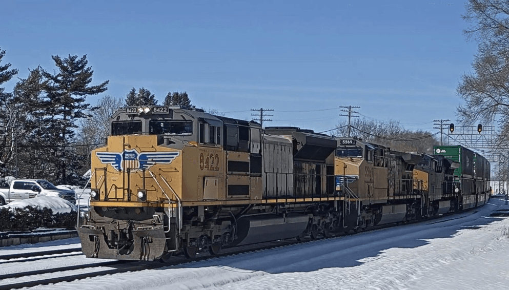
The monitoring system protected adjacent active Caltrain and UPRR rail corridors during installation of support of excavation (SOE), mass excavation to 85 feet, and eventual advancement of a 54-foot diameter Tunnel Boring Machine (TBM). Key deliverables included:
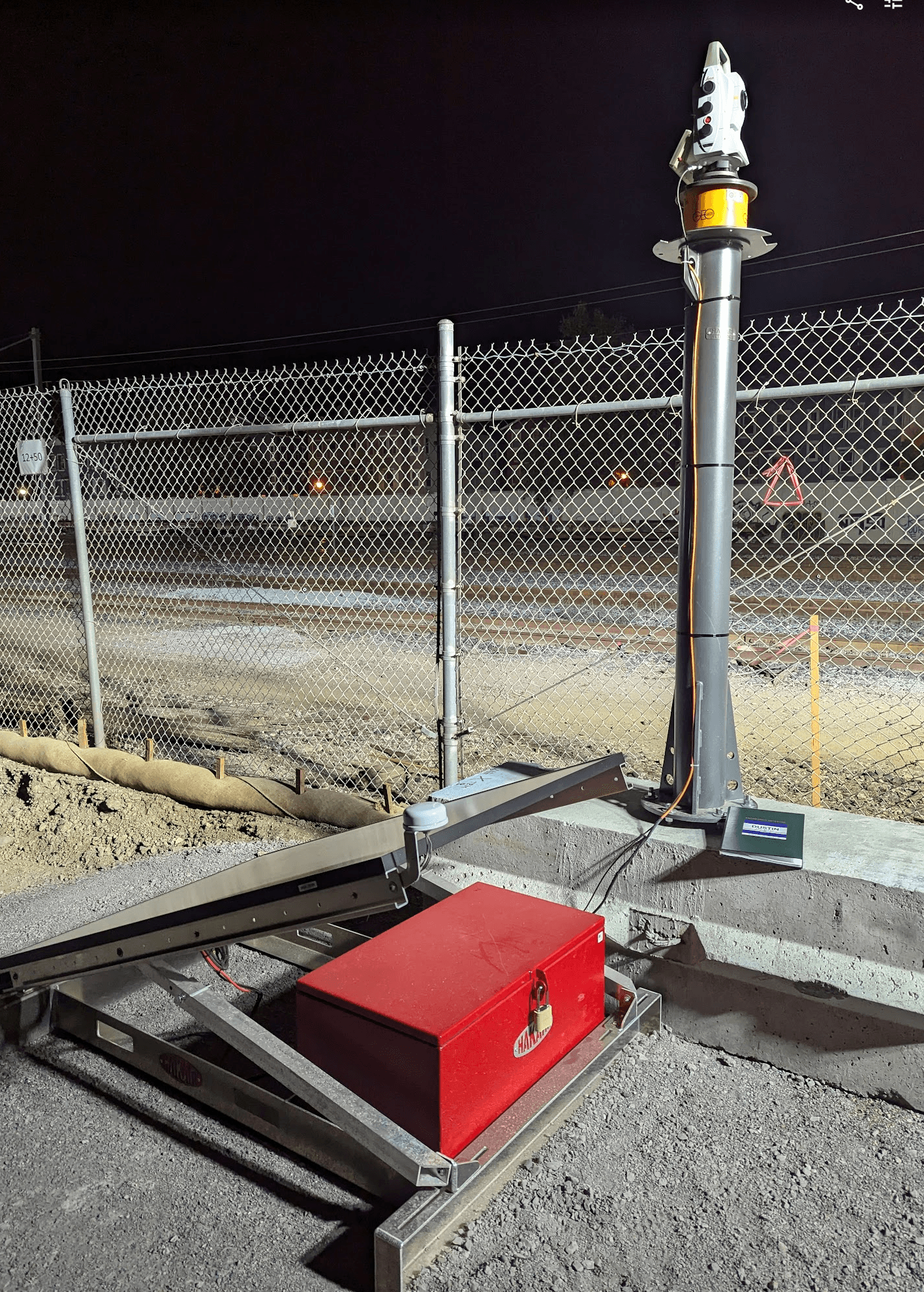
Design and installation of four (4) Leica TM60 1" Automated Monitoring Total Stations (AMTS) for real-time, high-precision optical survey monitoring.
Deployment of 439 rail monitoring prisms and 7 surface monitoring points across seven active rail tracks within the settlement zone of influence.
Integration with GeoComp's iSite Central data management system for real-time data transmission, processing, and web-based visualization.
Execution of a 90-day baseline monitoring program generating a dataset of nearly 1,000,000 unique data points.
Data Analytics and Engineering Recommendations
Custom data pipeline: Developed Python and SQL scripts to extract data from the GeoMOS database, compute statistical characterizations for all 439 prisms, and generate box-and-whisker plots and time-series visualizations by AMTS and by track.
Outlier classification system: Created a quality-tier methodology (high, moderate, marginal, outlier) based on the standard deviation of standard deviations, enabling the Engineer of Record to set informed alarm and warning thresholds.
System optimization recommendations: Delivered corrective actions including monument base stabilization, conversion to known-point orientation mode, modified rain hood installation to reduce solar loading, meteorological sensor integration, and reference prism network enhancements.
During the specification-required 90-day baseline monitoring period (July 28 – October 26, 2024), multiple significant issues threatened to invalidate the baseline and force a costly restart — potentially adding 90+ days to the project schedule:
During the specification-required 90-day baseline monitoring period (July 28 – October 26, 2024), multiple significant issues threatened to invalidate the baseline and force a costly restart — potentially adding 90+ days to the project schedule:
AMTS 2 monument settlement (September 9, 2024): Construction-induced ground settlement displaced the AMTS monument. The auto-leveling tribrach masked the disturbance, causing the system to report false track movement rather than flagging an instrument problem. A train simultaneously parked on the tracks blocked reference prism sight lines, preventing standard freestation checks.
Long-term railcar storage (September 23, 2024): Rolling stock placed in long-term storage on the JPB Drill Track blocked lines of sight between AMTS units and both monitoring and reference prisms, reducing data collection across all four stations.
Rail maintenance disruptions: All MT2/6000-series prisms had to be removed and taken offline during August 3–6 rail grinding operations.
Through rigorous data analysis, the LIME demonstrated that the baseline remained valid despite these events, avoiding a full baseline restart. The key technical work included:
Root-cause diagnosis: Correlated the apparent prism movement with nearby construction activity schedules and manual survey data (provided by Kier & Wright) to prove that the displacement was in the AMTS monument — not the track or rail prisms.
Data normalization: Separated AMTS 2 data into pre-settlement (before September 9) and post-settlement (after September 23) datasets, normalizing both to zero to eliminate AMTS movement as a variable and enable valid comparison to the rest of the baseline.
Specification compliance argument: Cited the specification's distinction between "Instruments" (AMTS, Section 3.4.2.a), "Prisms" (Section 3.3.3.c), and "Measurements" (Section 3.4.2.c) to demonstrate that 90 days of continuous AMTS operation — with 24 readings per day (12× the required frequency) — satisfied both the intent and the letter of the specification.
Actionable mitigation plan: Documented all issues as correctable within the scope of post-baseline work, with proposed solutions implementable prior to construction start without the need to re-establish baseline.
The final baseline report concluded: "This baseline report is valid and fully compliant with the requirements set out in the I&M specifications and Technical Requirements. The issues identified herein are all correctable within the scope of the post-baselining work."
Scope of Services
The monitoring system protected adjacent active Caltrain and UPRR rail corridors during installation of support of excavation (SOE), mass excavation to 85 feet, and eventual advancement of a 54-foot diameter Tunnel Boring Machine (TBM). Key deliverables included:
Design and installation of four (4) Leica TM60 1" Automated Monitoring Total Stations (AMTS) for real-time, high-precision optical survey monitoring.
Deployment of 439 rail monitoring prisms and 7 surface monitoring points across seven active rail tracks within the settlement zone of influence.
Integration with GeoComp's iSite Central data management system for real-time data transmission, processing, and web-based visualization.
Execution of a 90-day baseline monitoring program generating a dataset of nearly 1,000,000 unique data points.
Data Analytics and Engineering Recommendations
Custom data pipeline: Developed Python and SQL scripts to extract data from the GeoMOS database, compute statistical characterizations for all 439 prisms, and generate box-and-whisker plots and time-series visualizations by AMTS and by track.
Outlier classification system: Created a quality-tier methodology (high, moderate, marginal, outlier) based on the standard deviation of standard deviations, enabling the Engineer of Record to set informed alarm and warning thresholds.
System optimization recommendations: Delivered corrective actions including monument base stabilization, conversion to known-point orientation mode, modified rain hood installation to reduce solar loading, meteorological sensor integration, and reference prism network enhancements.
Results
Average standard deviations across the four AMTS units ranged from 0.028 in to 0.139 in, with per-track averages from 0.042 in to 0.133 in, demonstrating the system's capability to meet project specifications with the recommended modifications. The system was confirmed ready to monitor the excavation upon completion of the proposed post-baseline improvements.
Project Significance
This project demonstrates expertise in automated deformation monitoring for active rail corridors adjacent to major underground construction. The LIME's diagnostic and analytical work under challenging field conditions — actively settling monuments, blocked sight lines, and multi-railroad operational constraints — preserved the 90-day baseline and protected the construction schedule from a potentially significant delay.
Other Interesting projects

Hanksville Diversion

Salt Lake Temple Renovation
Salt Lake Temple Renovation
Other Interesting projects
Hanksville Diversion

Salt Lake Temple Renovation